How Drone‑Based 3D Modelling Is Shaping the Future of Land Development in Ontario
Forget everything you know about land development surveys. Traditional methods often slow your project down and leave gaps in data accuracy. Drone 3D modelling now delivers survey-grade precision, rapid site progress monitoring, and rich visual insights that fit straight into your CAD and BIM workflows. Here’s how Hoverscope Aerial Imaging reshapes your approach with safer, faster, and cost-effective aerial photogrammetry tailored for Ontario’s land development needs. Learn more about the impact of drones on land surveying here.
Precision and Speed in Land Development

Imagine a world where land development is faster and more accurate. That’s where drone technology comes in. With drone 3D modelling, your projects can achieve remarkable precision and speed.
Drone 3D Modelling for Accuracy
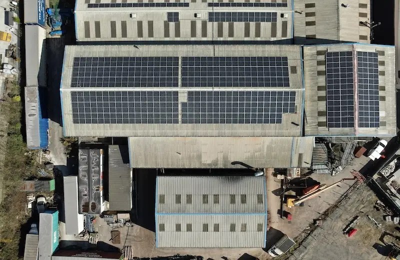
When you think of survey-grade accuracy, drones might not be the first tool that comes to mind. Yet, they consistently deliver precise results. Drones capture detailed site data from above, offering a top-down view that traditional methods might miss. The high-resolution images they provide are invaluable for creating accurate 3D models. These models ensure every inch of your site is accounted for, reducing errors and improving planning. Interested in the advantages of using drones for 3D mapping? Check out these insights.
Rapid Site Progress Monitoring
Keeping an eye on site progress is crucial. Drones make this task easier and more effective. With regular flyovers, drones capture real-time updates of your site. This constant monitoring means you can spot issues early and make timely decisions. No more waiting for scheduled reports; drones provide the updates you need now. This proactive approach saves time and keeps projects on track.
RTK PPK Drone Mapping Benefits
For even greater precision, RTK and PPK mapping techniques are key. These advanced methods ensure your maps are as accurate as possible. RTK drones use satellite data to pinpoint exact locations, while PPK offers post-processing accuracy. Together, they provide a level of detail unmatched by other methods. This precision supports better decision-making and project outcomes.
Safety and Cost Advantages
Beyond precision and speed, drones offer significant safety and cost benefits. They ensure operations are safe, compliant, and economically efficient.
Transport Canada Compliant Operations
Safety is paramount in drone operations. All Hoverscope flights are compliant with Transport Canada regulations. This adherence guarantees that all safety protocols are followed, protecting both people and property. Operating within these guidelines not only ensures safety but also builds trust with clients and stakeholders.
Cost-Effective Aerial Photogrammetry
Drones offer a cost-effective solution for aerial photogrammetry. Traditional methods can be expensive and time-consuming, but drones change the game. By capturing detailed images quickly, drones reduce the need for extensive manpower and equipment. This efficiency translates to cost savings, making high-quality mapping accessible for more projects.
Efficient Stockpile Volumetrics
Accurately measuring stockpiles is another benefit of drone technology. Traditional methods can be inaccurate and slow. However, drones quickly and precisely calculate the volume of materials on site. This efficiency ensures you know exactly what resources you have, aiding in project planning and inventory management.
Seamless Integration into Workflows

Drone data isn’t just accurate and cost-effective; it’s also easy to integrate into your existing workflows.
BIM Integration and CAD Ready Deliverables
Drone data fits seamlessly into BIM and CAD systems. The models and maps drones produce are ready for immediate use in these platforms. This integration streamlines your workflow, reducing the time between data collection and project application. Discover more about how drones integrate into construction workflows here.
Georeferenced Point Cloud and Orthomosaic Mapping
Drones generate georeferenced point clouds and orthomosaic maps, providing a detailed and accurate representation of your site. These outputs are crucial for precise planning and analysis. By offering a clear visual of the terrain, drones help uncover insights that guide better decision-making.
Digital Twin for Enhanced Stakeholder Visualisation
Creating a digital twin of your site offers unparalleled visualisation. Stakeholders can explore a virtual model of the project, making complex data accessible and understandable. This transparency enhances collaboration and allows for more informed decision-making, driving project success.
By embracing drone technology, you’re not just adopting new tools—you’re transforming how land development is approached. The precision, safety, and integration benefits they offer ensure your projects are efficient, accurate, and ready for success. Dive into more benefits of using drones for land development here.