Aerial Mapping Services in Ontario: What Businesses Need to Know Before Booking
Most businesses booking aerial mapping Ontario underestimate the complexities involved. You need more than just a drone flying over your site. Precision, safety, and clear deliverables make all the difference between useful data and costly errors. This guide breaks down what you must know before commissioning drone mapping services Ontario, helping you secure reliable, GIS-ready results every time. For more insights, check this discussion on aerial mapping applications.
Understanding Aerial Mapping Services
Aerial mapping can transform the way you approach projects. But what exactly does it offer? Let’s dive into the benefits and safety measures you should expect.
Key Benefits for Businesses
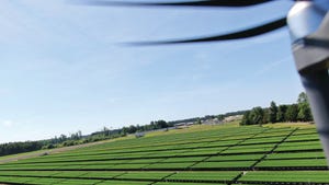
Aerial mapping isn’t just about taking pictures from above. It brings a range of advantages that can boost your operations. First, it offers precise topographic mapping. This means you get accurate land measurements without the need for extensive on-ground surveys.
For those in agriculture, farm field mapping can help monitor crop health efficiently. You’ll have detailed data on soil conditions and plant health. Construction teams will find value in progress monitoring drones. These devices keep track of site changes, helping with planning and execution. Lastly, using 3D modelling by drone provides comprehensive models for planning and analysis. This is crucial for architects and planners.
The takeaway? Aerial mapping provides practical solutions, making your processes smoother and more effective. Ready to see it in action for your business? Keep reading to ensure safety and compliance.
Ensuring Safety and Compliance
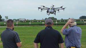
Safety and compliance are crucial. You can’t overlook them when hiring drone services. Canadian regulations are strict, especially with Transport Canada compliant drone operators. They ensure safe operations in the sky.
Here’s what you need to check: Is the provider licensed? A licence is non-negotiable. It guarantees that the operator follows all safety protocols. Next, look at how they plan flights. Proper pre-flight planning essentials include assessing weather and flight paths to minimise risks. Finally, think about insurance. It’s a safety net for any mishaps.
Why is all this important? Without it, you risk project delays or penalties. Making sure your provider ticks these boxes will save you headaches down the road. Curious about choosing the right provider? Let’s explore that next.
Choosing the Right Drone Mapping Provider

So, you know the benefits and the safety checks. But how do you choose the right provider? Evaluating service offerings is key. Let’s explore.
Evaluating Service Offerings
Choosing a drone mapping service means looking beyond just price. What services do they offer? Comprehensive options should include orthomosaic mapping and RTK drone surveys. These ensure the data you get is accurate and useful.
Talk to them about their technology. Providers using the latest drones and software deliver better results. Look for those who offer GIS-ready deliverables. This makes integrating data into your existing systems easier. Don’t forget customer service. A provider should be responsive and open to tailoring services to your needs.
In short, evaluate them based on technology, service range, and customer care. These factors will guide you to a provider who understands your unique needs. Now, let’s discuss accuracy and precision—critical for any mapping project.
Importance of Accuracy and Precision
Accuracy sets apart good mapping from great mapping. It’s about getting precise results every time. For this, precision drone surveys are indispensable. They ensure every centimetre is accounted for.
Look at their track record. Have they worked on similar projects? Client testimonials can also provide insights. Check their equipment: drones with contour mapping capabilities offer detailed land analysis. And don’t underestimate the power of volumetric stockpile surveys. These are useful for managing resources in mining and construction.
The bottom line? Accuracy impacts decision-making. A reliable provider will offer precision, ensuring your project is on the right path. Before you book, consider some practical steps.
Practical Considerations Before Booking
Before you make a booking, think about practical elements. Good planning and understanding deliverables are vital for success.
Pre-Flight Planning Essentials
Pre-flight planning should never be rushed. It involves more than just scheduling a date. Weather conditions can change plans quickly. Ensure your provider considers this. A detailed flight plan includes site surveys and risk assessments, crucial steps in UAV survey Ontario.
Communication is key. Discuss your project goals and constraints early. This avoids misunderstandings later. Agree on timelines and deliverables. A clear contract protects both parties and sets expectations.
These steps may seem tedious, but they pave the way for a smooth project. They ensure you get the data you need, on time and within budget. Now, let’s move on to understanding the outputs you should expect.
Understanding Deliverables and Outputs
Knowing what to expect from your mapping service is crucial. Deliverables should be clear and aligned with your goals. You’ll often receive maps, models, and reports. These should be in formats compatible with your software.
Look at the detail in the outputs. Are they GIS-ready deliverables? This ensures seamless integration with your systems. For agriculture, agricultural drone mapping outputs might include crop health indices. Construction projects may receive construction site mapping data, detailing progress and changes.
Clarify any uncertainties before the project starts. This avoids future surprises. The right deliverables lead to informed decisions, enhancing your project’s success. Ready to take the next step? Engage a reliable provider today to see these benefits unfold.
For more in-depth industry insights, refer to this comprehensive report on the drone industry, which outlines growth prospects and technological advancements.