Forget the days when land planning meant slow, costly surveys and guesswork. With drone mapping Ontario farms and construction sites gain pinpoint accuracy and fast, reliable data that keeps projects on track and under budget. You’ll see how orthomosaic maps, DSM/DTM elevation models, and 3D modelling improve your planning and reduce risk—plus why Hoverscope Aerial Imaging is the partner you can trust to bring this precision to your fields or sites.
Enhancing Accuracy with Drone Mapping
Imagine saving time and money while achieving more precise results in your projects. Drone mapping offers just that, providing the accuracy needed in both agriculture and construction. Let’s explore how these advancements can transform your work.
Precision Agriculture Techniques
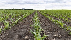
Farming isn’t just about planting and harvesting anymore. With agricultural mapping using drones, you gain detailed insights into your fields. These insights help identify problem areas early. For example, drones equipped with NDVI sensors can detect crop health, showing you which sections need attention. By monitoring chlorophyll levels, you can take action before problems escalate.
Field scouting by drone changes how you manage crops. Instead of walking rows, you receive data directly to your device. This data allows you to make informed decisions, from applying fertilisers only where needed to adjusting irrigation systems. Contour mapping also helps in planning planting strategies on uneven terrain. It’s like having a bird’s eye view that spots details you might miss from the ground.
Construction Site Mapping Benefits
Construction projects benefit greatly from drone technology. Think about how construction site mapping creates detailed terrain models. These models help in planning, reducing the chances of construction errors. Using DSM/DTM elevation models, you can plan cuts and fills with precision. This saves resources and ensures structures are built on stable ground.
Progress monitoring construction projects becomes easier with aerial views. By using photogrammetry, you get real-time data to track progress and make necessary adjustments. Aerial survey services offer a level of detail and accuracy that traditional methods struggle to match. This translates to fewer delays and a more streamlined project timeline.
Speeding Up Workflows Efficiently

Fast, reliable data is crucial for keeping your projects on track. Drones excel at providing this, speeding up workflows across various applications. Here’s how rapid mobilisation strategies and fast turnaround times can redefine efficiency in your projects.
Rapid Mobilisation Strategies
Imagine starting your day with all the data you need at your fingertips. Drone technology enables this with quick deployment capabilities. Traditional surveying methods are often slow and require significant manpower. Now, a single drone flight can cover large areas swiftly, capturing data that would take days to collect manually.
This rapid data collection is essential in situations where timing is critical. For instance, after a severe weather event, drones can quickly assess damage and help plan recovery efforts. Transport Canada compliant operations ensure safety and regulatory adherence, so you can focus on what matters—getting the job done efficiently.
Fast Turnaround Times
The speed at which you receive data impacts how well you can respond to changes. With drones, turnaround times are short, enabling quicker decision-making. In agriculture, this means you can adjust practices in real-time, improving crop outcomes. In construction, it reduces downtime by allowing you to address issues before they snowball.
Imagine a construction site where daily updates inform every team member. This keeps everyone aligned and focused on delivering results promptly. RTK GNSS accuracy ensures the data you receive is reliable, further enhancing your ability to react swiftly and effectively.
Cost and Risk Reduction Advantages

Reducing cost and mitigating risks are top priorities in any project. Drone mapping offers significant advantages in these areas, enabling you to work smarter and safer.
Mitigating Construction Risks
Risk is part of any construction project, but drones help manage it better. With drones, you can assess potential issues before they become costly problems. For example, drones highlight areas prone to water pooling, allowing you to address drainage before laying foundations.
Using drones for cut and fill analysis provides precise measurements, reducing the risk of errors during earthworks. This precision minimises waste and helps keep projects within budget. Additionally, aerial views offer valuable insights for safety inspections, ensuring compliance with regulations and enhancing onsite safety protocols.
Cost-effective Agricultural Planning
In agriculture, every penny counts. Drone mapping provides a cost-effective way to manage resources. By identifying areas needing fertilisation, you reduce waste and optimise input use. This targeted approach not only cuts costs but also supports sustainable farming practices.
Drones also assist in volume calculations, helping track produce yield and storage requirements accurately. GIS/CAD integration ensures the data collected aligns seamlessly with existing systems, enhancing planning and analysis capabilities.
In conclusion, whether you’re involved in farming or construction, drone mapping significantly boosts your ability to plan and execute projects with precision, speed, and cost savings. Embracing this technology positions you ahead in efficiency and effectiveness, ensuring project success and profitability.