From Raw Capture to Decision‑Ready: Hoverscope’s Professional Drone Workflow
Raw drone footage alone doesn’t deliver the clear, reliable data your project demands. Turning that initial capture into decision-ready deliverables takes a professional drone workflow built for precision and compliance. In this post, you’ll see how Hoverscope’s methodical approach to drone mapping Ontario transforms aerial data into actionable insights your team can trust. Learn more here.
From Planning to Precision

A successful drone mission starts with careful planning. It’s not just about flying a drone; it’s about making sure every flight yields the best data possible.
Discovery and Scoping Essentials
Before the drone ever takes off, it’s crucial to understand your project’s specific needs. This step involves identifying the project’s goals and any challenges that might arise. By discussing these details with you, we ensure the flight plan aligns perfectly with your objectives. This is where we gather the details: what type of data is required, the area to be covered, and the timing.
Next, we carry out a site assessment. This step helps us to understand the terrain and other environmental factors. We consider weather patterns, obstacles, and any restrictions that might affect the flight. This thorough scoping ensures every detail is covered, making the data collection process as smooth as possible.
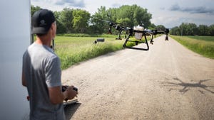
Pre-flight Planning Guidelines
Effective pre-flight planning sets the foundation for a successful mission. You might think drone flights are straightforward, but they require meticulous preparation. Our team follows a detailed checklist to verify all equipment is in top condition. We assess battery levels, camera settings, and ensure all software is up to date.
We also map out the flight path. Using advanced tools, we plan paths that maximize coverage and data quality. This step involves setting waypoints and flight altitudes. By planning these aspects carefully, we ensure the drone captures every necessary detail. Our goal is to leave no stone unturned, offering you comprehensive data for your project.
Sensor Strategy and Selection
Choosing the right sensor is pivotal. Different projects require different sensors, and selecting the appropriate one can dramatically impact the data’s usefulness. For instance, for agricultural mapping, sensors that capture NDVI crop health are essential. This ensures you get actionable insights into crop conditions.
For construction or surveying applications, high-resolution cameras help in creating detailed orthomosaic maps and 3D models. Selecting the right sensor aligns with your project’s specific requirements. This tailored approach means your data is precision-targeted, giving you the clarity you need to make informed decisions.
Capturing and Processing Data
Once the flight plan is in place, capturing and processing the data comes next. This phase transforms raw footage into valuable insights, crucial for decision-making.
Ground Control and Positioning
Ground control points (GCPs) are crucial for achieving survey-grade accuracy. Placing these markers accurately ensures the aerial data aligns perfectly with real-world coordinates. GCPs help in correcting any positional errors, providing you with precise data. When combined with RTK or PPK technology, accuracy is enhanced further, making it ideal for projects requiring exact measurements.
Positioning is key, and our team excels in this area. By setting these points strategically, we ensure your maps and models reflect true dimensions and positions. This level of detail is what sets professional photogrammetry apart, providing reliable data you can trust.
Secure Data Handling Practices
Data security is paramount in our operations. After capturing, data is securely transferred to our processing systems. We use encrypted channels to prevent any unauthorized access. This ensures your project’s data remains confidential and protected at all times.
Once securely transferred, the data undergoes initial processing. This involves organizing and backing up raw footage to prevent any loss. Our commitment to secure practices gives you peace of mind, knowing your data is in safe hands. With every project, we adhere to strict protocols, ensuring both data integrity and confidentiality.
Photogrammetry and Analytics
Photogrammetry is where the magic happens. By processing images through specialized software, we create detailed 3D models and maps. These models provide insights into terrain, structures, or vegetation health. For example, in agriculture, NDVI analysis can reveal crop health patterns, guiding effective interventions.
Analytics further enhance the value of your data. By applying advanced techniques, we extract actionable insights tailored to your project’s needs. This process transforms raw data into decision-ready outputs, making it easier for you to strategize and act confidently.
Delivering Decision-Ready Outputs

The final stage ensures the data we collect is not just accurate but ready to be used effectively.
Comprehensive QA/QC Process
Quality assurance is the backbone of our delivery process. We rigorously check all data for accuracy and completeness. This step involves cross-referencing with ground data and verifying measurements. It’s a thorough process that ensures no detail is overlooked.
Quality control means you receive data you can trust. Our meticulous approach guarantees that what you get is both reliable and actionable. This commitment to excellence underpins every project, reinforcing our promise of precision.
Diverse Deliverables for Clients
We cater to varied needs by offering a range of deliverables. From orthomosaic maps to 3D models, each output is tailored to meet specific project requirements. For construction, this might mean detailed 3D models for planning. In agriculture, it could be vegetation health reports.
Our goal is to provide you with the tools you need to succeed. By customizing outputs, we ensure you have the precise data to drive informed decisions. This adaptability is key to addressing the diverse challenges across different sectors.
Integration and Client Support
Our commitment doesn’t end with delivery. We integrate seamlessly with your existing systems, ensuring you can use the data effectively. Whether it’s GIS software or project management tools, our deliverables are compatible with your workflows.
Client support is also a priority. We are here to assist with any queries or additional needs you might have. From understanding the data to implementing it in your projects, our team is ready to support your success every step of the way.
In summary, Hoverscope’s professional drone workflow is designed to deliver precision, reliability, and actionable insights. By focusing on every detail from planning to processing, we transform raw data into decision-ready outputs. This commitment to excellence ensures you have the confidence to make informed decisions, driving success in your projects.