Spring Drone Surveying for Agriculture and Construction: What to Look For
Spring drone surveying is your best tool to start the season with precision. Whether you manage crops or construction sites in Ontario, timing, accuracy, and compliance can make all the difference. This guide breaks down what you need to look for—from sensor choices to deliverables—so your spring drone surveying delivers clear, actionable data right when you need it. Ready to capture the season from above? Check this guide for more insights.
Timing and Compliance Essentials
Starting your spring survey with the right timing and compliance measures ensures effective results. Let’s explore the key factors for a successful drone survey this season.
Optimal Spring Survey Timing
When it comes to spring surveying, timing is everything. The best time to start your drone survey is when weather conditions are stable and predictable. Clear skies and calm winds provide the ideal environment for capturing high-quality data. This is especially true in agriculture, where early planting stages are crucial. Starting your survey during this period allows for accurate field boundary mapping.
For construction projects, beginning your drone survey early in the season helps in establishing baselines for progress monitoring. This ensures you can track changes and make data-driven decisions throughout the project lifecycle. Keep an eye on weather forecasts to pick the perfect surveying windows. The earlier you start, the more comprehensive your data will be.
Navigating Airspace and Permissions
Navigating the complexities of airspace regulations can seem daunting. However, understanding these regulations is essential for a compliant and hassle-free survey. Firstly, ensure compliance with Transport Canada regulations. This includes obtaining necessary permits and permissions. Familiarize yourself with local airspace classifications to avoid violations.
Using platforms like Drone Spray Pro can assist in understanding specific legal requirements for your area. Always check for temporary flight restrictions and no-fly zones before launching. Knowing these details protects you from legal issues and ensures a smooth survey experience.
Safety and Risk Assessments
Safety should be a top priority for every drone survey. Begin by conducting thorough risk assessments of the survey area. Identify potential hazards such as power lines, tall structures, or unpredictable wildlife. Ensuring your equipment is in top condition is also crucial. Regular maintenance checks help prevent technical failures during flights.
Incorporate safety guidelines into every stage of your survey. Establish clear communication protocols with your team, and always have an emergency response plan in place. By prioritising safety, you not only protect your equipment but also ensure the well-being of your team and those around you.
Ensuring Precision and Accuracy
Accurate data collection lies at the heart of any successful drone survey. Let’s delve into the methods that guarantee precision and reliability.
RTK/PPK and Ground Control Points
RTK and PPK technologies elevate the accuracy of your drone surveys. These systems provide centimetre-level precision by correcting positional errors in real-time or post-processing. Integrating these technologies into your workflow ensures your data is both accurate and reliable.
Ground Control Points (GCPs) further enhance data precision. These are marked locations on the ground used to geo-reference your drone data. Using GCPs helps improve the alignment of your survey outputs with real-world coordinates. By combining RTK, PPK, and GCPs, you achieve a higher degree of accuracy for tasks like site grading.
High-Accuracy Orthomosaic Mapping
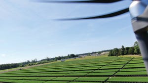
Creating high-accuracy orthomosaics is a game-changer for drone surveying. These detailed maps stitch together multiple images to form a comprehensive view of the surveyed area. The precision of orthomosaic mapping is crucial for applications like construction planning and land management.
Using software that supports advanced mapping techniques can significantly enhance the quality of your orthomosaics. This process involves taking overlapping images and utilising algorithms to correct distortions. High-accuracy orthomosaics are invaluable for 3D modelling point cloud creation and other precision-demanding tasks.
Quality Assurance and Control
Implementing quality assurance measures is essential for maintaining high data standards. Regularly calibrating your drone’s sensors ensures consistent data quality across different surveys. Developing a checklist for pre-and post-flight inspections can help identify any discrepancies early.
Incorporating a feedback loop into your survey process allows for continuous improvement. Review each survey’s outcomes to identify areas for enhancement. By prioritising quality control, you not only ensure the reliability of your data but also build trust with your clients and stakeholders.
Tailored Deliverables and Benefits
Providing customised deliverables tailored to your clients’ needs is key to a successful drone survey. Let’s explore the deliverables that add value to your projects.
Customised GIS and CAD Outputs
Customised GIS and CAD outputs transform raw survey data into actionable insights. These deliverables are essential for clients in construction and agriculture who require detailed maps and models. Offering outputs like GeoTIFFs and shapefiles provides the flexibility needed for various applications.
Delivering tailored outputs ensures your clients can seamlessly integrate data into their existing workflows. This capability is especially beneficial for drainage assessment mapping and other site-specific analyses. Customisation not only enhances client satisfaction but also positions you as a versatile service provider.
Comprehensive 3D Modelling and Mapping
3D modelling and mapping are powerful tools for visualising complex environments. These models provide an in-depth view of surveyed areas, useful for construction planning and progress monitoring. Advanced software can help create detailed point clouds and digital surface models.
By offering comprehensive 3D models, you provide your clients with a clearer understanding of their projects. This visualisation aids in decision-making and enhances communication among project stakeholders. Comprehensive mapping is a valuable asset for DSM DTM contours and other intricate tasks.
Leveraging Multispectral Imaging for Agriculture
Multispectral imaging is revolutionising agricultural surveys. This technology captures data across various spectral bands, revealing insights invisible to the human eye. It is particularly useful for crop health assessments and NDVI mapping.
Using multispectral imaging allows for early detection of issues such as nutrient deficiencies and pest infestations. The data collected enables precise interventions, enhancing crop yield and quality. Offering multispectral services positions you as a leader in emergence counts and other critical agricultural applications.
Embracing these tailored deliverables ensures your clients receive the most value from their drone surveys. By focusing on precision, compliance, and customisation, you set the stage for a successful spring survey season.